
WOW! After the Sisters Loop 2 weeks ago with feet and feet of snow on the west side, I took another – leaving Aug 1, a 6 day PCT hike both directions (north and south) covering as much of the Central Cascades as possible, traveling through all 3 wilderness areas, Three SIsters, Mt Washington, and Mt Jefferson. Given the PCT closure at Pamelia Lake (Lionshead fire from PCTA), the hike could only go north to the southern slope of Mt Jefferson … and south as far as Reese Lake on the northern slope of South Sister. The original plan had day 1-2 above Santiam Pass, and day 3-6 below the pass … the actual hike was close to plan.
Day 1 and 2: Big Lake (Santiam Pass generally) north to Jefferson, and south to Washington
Big Lake trailhead was chosen as the starting point for both easy highway access for passenger car and going north or south on PCT provides challenges and views very quickly (also enabled day 2 restock from car, lighter pack :)). Day 1 had hazy atmosphere with cooler temperatures than the scorchers previously.


All the way from Santiam to the western slope of 3-Finger Jack, the PCT winds up a ridge through older burns. Looking down at the lakes and meadows within the burns just begs the question of what it looked like BEFORE.


Climbing up the shoulder of 3-Finger Jack winds around the western slope and on both days I had observers. Unfortunately, they were about 1/2 way up slope day 1 and 1/3 the way day 2, so the pics are not as good as desired. This family group is probably the same I saw last year and had grown to ~20 individuals.


At the end of day 1, there were about 25 PCT hikers heading to the closure to camp for the night and there are not that many campsites, so I stayed the night with several others at Rockpile Lake after going north to base of Jefferson and returning.

Day 2 morning dawned strangely but quickly cleared for the trip back around Jack.


The second time coming around Jack, I realized that just like Broken Top (and South) there is a ‘crater’ lake at the base. I just couldn’t see it from the south.

Swinging around Jack, the view south to Washington & Sisters opened up. I stopped at car to restock and then camped at Mt Washington meadow on PCT – there were 5 tents that night too.


Day 3: PCT sobo Mt Washington to Reese Lake
This was going to be a tough day – the lava beds between Washington and McKenzie Pass, as well as Scott Pass sobo and going down the wall of Modor. Morning was clearer than the previous 2 days, so …


Closer to the lava beds, Sisters put on a cloud show; couldn’t tell at one point if 1 or 2 mountains. Every 5 minutes it would change, and I swear mountains create clouds.


This ground (PCT sobo from McKenzie Pass to Reese Lake) was covered in Sisters Loop, but then there were feet of snow; this week, absolutely no snow on the trail, streams were dry, but wildflowers were popping. Before Reese Lake, however, were two lava obstacles: a) the lava beds and b) wall of mordor.


Left pic is the lava beds and for reference, a human who is not even 25% across; the full lava bed on PCT is >5 miles of wandering thru those rocks up and then down. The right pics are the wall of mordor; top is looking over the edge where it drops, and bottom is looking up the wall. There are 26 switchbacks top to bottom.
Day 4: Sightseeing (Chambers Lakes, Camp Lake and Linton Meadows)
After 3 days of non-stop challenges and 20+ mile days, I was ready for a rest / tourist sightseeing day. Starting early at Reese Lake, part 1 was to climb the saddle between Middle and South Sisters to the Chambers Lakes and Camp Lake. Morning at Reese Lake almost always enables a South Sis show.


The two Chambers lakes are to the west and Camp, obviously to the east where I was blocked by snow two weeks ago. Reaching the rim of the first lake, snow and ice remained.


Camp Lake is on the other side of the Frazier Upland (~7500 ft) from the other lakes. Camp Lake tends to be the popular destination for camping, but there are only 3-4 good sites on the ridge overlooking the lake on the left (north) side.


Just in case you have not grokked the amount of snow … that wall was about 20 ft at its highest.

The wind was so strong that hanging out at the lakes was like a weird torture, so I head back down the hill to Reese Lake and then finally to Linton Meadows to camp for the night. Linton Meadows are gorgeous; lush green filled with flowers and a raging mountain creek. I was the only human in the meadows that night.


Day 5: PCT nobo Linton Meadows trail to Mt Washington (same campsite as Day 2)
A repeat hard day going over Scott Pass, wall of Mordor, and the Lava Beds to get back to Mt Washington. There were options to make this a short day (e.g., camping at Lava Camp), but this challenge was too good to pass. There was 1 hiker ahead of me and 1 behind as most PCT hikers were sidelined due to Windigo Fire.
Once again, the Sisters put on a dance with the clouds in the early morning that was amazing.


Then it was across the lava, and I was tired with very sore feet … but the views certainly helped get across.


After that long day, Mt Washington meadows were very welcome, and another hiker joined me for a quiet evening.

Day 6: Mt Washington to Big Lake (car)
An early am departure from Mt Washington and a cruise down hill to the car. Still, views and perspectives were fab, and the bear grass spiked to say good bye!


If all of that was not enough, the wildflowers were just popping almost everywhere.
The gallery was not found!Summary
The Central Cascades portion of the PCT is probably the best part of PCT: OR. This hike started at Big Lake, nobo to Jefferson; sobo to South Sister and back nobo to Big Lake – with a couple of side trips add in: Camp Lake and Linton Meadows. While the landscape can seem similar Jefferson to South Sis, a careful observer will see the differences. With the snow gone, everything was different. The best parts on the PCT are surely 3-Finger Jack and Sisters (Mini Scott Spring to Mesa Creek). The side trip to Chambers and Camp Lakes is an adventure in and of itself and is not to be missed. Linton Meadows is gorgeous, but hardly worth a separate trip to stay there; incorporate it into another hike.
Traveling both nobo and sobo gave me both views and perspectives not typically seen, as well as the difference of hiking with and against traffic. Against traffic (sobo) is more social, but nobo is much more private and quiet …. Mt Jefferson remains under-explored for me and along with Broken Top are top destinations for next season.
Best human: A couple had doggie socks and a water-cooled jacket on their dog hiking around Middle Sister (Obsidian Trail). So many people take their dogs to high elevation and dangerous terrain without proper gear for the dog. This couple was originally from Alaska and knew how to take care of their dogs. Would the rest of you get a clue?
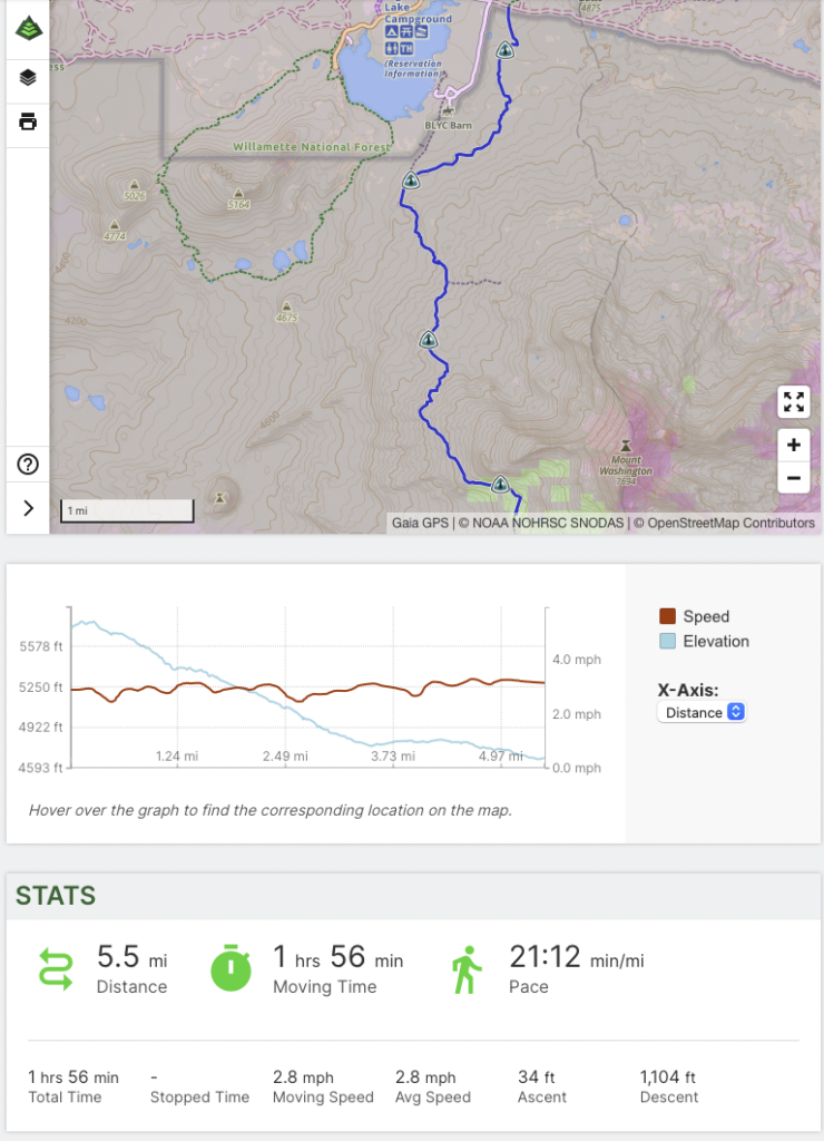
GaiaGPS Stats
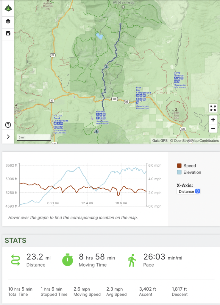
Day 1
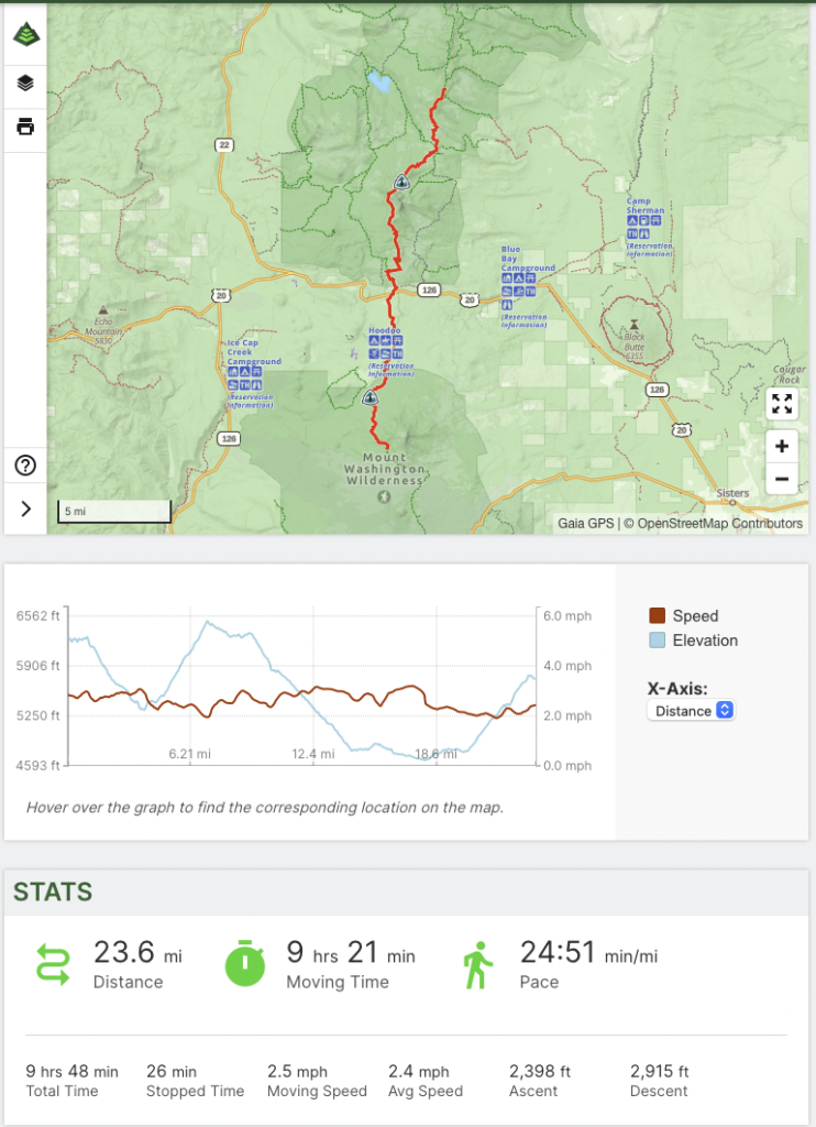
Day 2
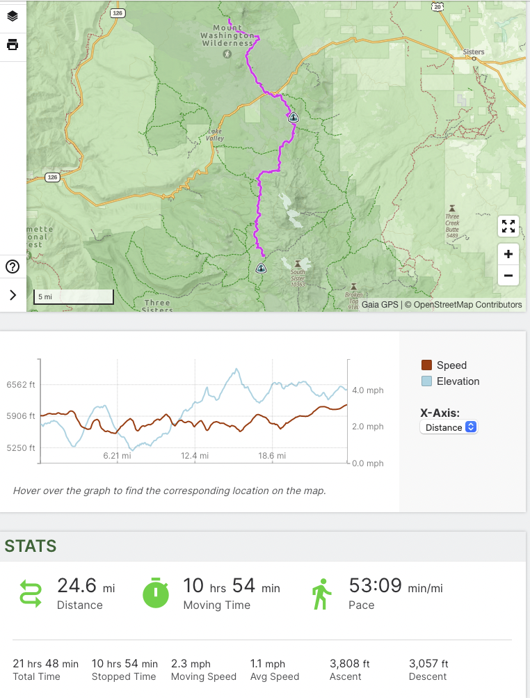
Day 3 (note: these stats seem off – stopped time)
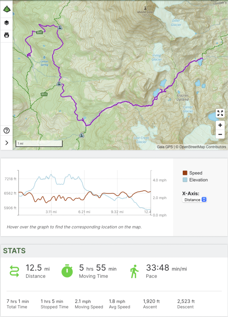
Day 4
Day 5
Day 6
[…] (for at least this year), an opportunity to put more PCT miles onto the Jefferson / 3 Finger Jack hike from earlier this year. The day started at dawn from the popular Pamelia Lake TH (one of the […]
Tell me more about the sore feet! And, not familiar with the word “mordor” so tell me more! Every time there are different sites it seems. How do you know if and when you find your soul? Love, Mom
Mordor is from Lord of the Rings … the evil kingdom of doom, darkness and volcanoes … just like … I find my soul after 15 minutes in the woods – it sings!